
Cascade Falls
Ontario • Pukaskwa National Park
By Armen Suny · Last verified Jun 2026
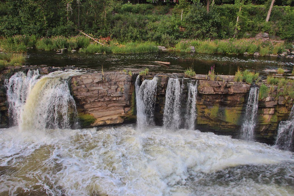


Photo Credits (5)
About Cascade Falls
Cascade Falls is a modest multi-tiered cascade located in the boreal forest region north of Marathon, Ontario (coordinates approximately 48.1335, -86.0467). Flow and appearance are highly seasonal: peak flow is typically in spring during snowmelt and after heavy rains, while summer and fall often have lower flows. The falls appear as a series of small drops and chutes rather than a single tall plunge. Exact official signage, developed viewpoints, or interpretive facilities at the site may be limited or absent.
The Setting
Cascade Falls sits at 204 metres within Pukaskwa National Park, in the foothills of Ontario.
Nearby Falls Worth Visiting
Swallow River Falls (2 m) lies 5.0 kilometres to the northwest.
Trail & Hike Details
Trail Description
Trail conditions vary and may range from a short, informal footpath from a roadside pullout to a somewhat brushy, uneven approach through mixed forest. Expect natural surfaces, roots, rocks, and potentially wet or muddy sections near the stream. There may be limited or no maintained boardwalks, railings, or marked viewpoints. Follow established boot-worn routes where present and avoid creating new trails that damage vegetation or destabilize banks.
What to Expect
A series of small cascades and drops over bedrock with areas of exposed rock and shallow plunge pools. Water clarity and volume depend on season, spring runoff and rainy periods produce the most dramatic flows. Surrounding terrain is typical boreal forest (conifers and mixed hardwoods), with mosses and lichens on shaded rock faces. Cell coverage can be spotty or non-existent in remote areas.
Accessibility
Access is likely not wheelchair accessible. Terrain to the falls may be uneven, rocky, and include short steep sections; use caution. There may be little or no formal infrastructure for visitors with mobility limitations.
Frequently Asked Questions
🐶 Are Dogs Allowed at Cascade Falls?
❌ Dogs are not allowed
Are There Any Fees or Permits Required?
🆖 No fees required
🏊 Is There Swimming at Cascade Falls?
❌ Swimming is not allowed
When to Visit
Late spring (snowmelt) for highest water flow and most dramatic appearance. Summer and early fall offer easier travel conditions with pleasant weather and fall colours. Winter can present a scenic frozen cascade but access may be difficult and hazardous; only attempt winter visits with appropriate equipment and experience.
Seasonal Access
The best time to visit is Spring, Summer, Fall, and Winter. Check with Pukaskwa National Park for current conditions.
Safety Information
Hazards include slippery rock and wet surfaces, unstable or undercut banks, fast-flowing water during spring runoff, cold water temperatures, seasonal road closures or poor road surfaces, limited cell coverage, and typical backcountry hazards (weather changes, insects, wildlife). Do not approach the edge of the falls or climb on wet rock. Travel with a companion when possible and share your plans with someone before heading into remote areas.
Current Water Conditions
These readings come from the Water Survey of Canada gauge on Pukaskwa River, 23.6 km away, not on Cascade Falls's own stream. Use them as a sign of whether the area is running wet or dry.
18.0 m³/s
Current discharge — how much water is flowing
Much higher than usual for this time of year
Based on 13 years of record
4.41 m
Water depth at gauge
7-Day Discharge Trend
What does this mean for your visit?
The water is flowing much higher than usual, expect an impressive display.
About This Gauge
This gauge is on a nearby waterway and may not reflect exact conditions at the falls.
7-Day Flow Outlook
Based on the WSC gauge PUKASKWA RIVER BELOW FOX RIVER (24 km away).
Today
Roaring
19 m³/s
6/10Tomorrow
Roaring
18 m³/s
6/10Fri
Roaring
19 m³/s
8/10Sat
Roaring
20 m³/s
8/10Sun
Roaring
21 m³/s
8/10Mon
Roaring
19 m³/s
8/10Tue
Roaring
17 m³/s
8/10Best window: Fri — roaring flow, cloudy (trip score 8/10).
Best time of year: this gauge typically runs highest from mid April to early June, peaking in May.
How we calculate this
This is a transparent outlook, not a precise forecast. We take the waterfall's current flow strength (how it ranks against its historical normal for today, from the nearest WSC stream gauge), carry that ranking forward along the gauge's seasonal curve, and nudge it for forecast rain. Confidence is highest for the next day or two and falls further out. Always check official conditions and your own judgment before visiting — high flows can be dangerous.
Know when to go.
Get a free email alert when waterfalls near Marathon hit peak flow. We only send when conditions are worth the trip — no weekly newsletters, no spam.
Is Cascade Falls Frozen?
Updated about 6 hours agoNot frozen highs above freezing lately
Cascade Falls is not frozen right now; highs have been above freezing. Yesterday ran 59°F to 53°F.
- Days below freezing
- 0 of the last 14
- Current cold streak
- 0 days
- Freezing days ahead
- 0 of the next 7
- Flow
- no gauge
Winter safety. Frozen falls are the one waterfall trip with a documented injury pattern: falling ice, and ice-glazed rock and trail. Wear microspikes, keep well back from the base and from overhangs, and never walk out on ice over moving water.
Estimate from Open-Meteo daily temperatures at the falls, the LiDAR-measured facing direction, and the nearest stream gauge. It is a likelihood, not a report from the trail.
Weather Forecast
Location & Access
Getting There
The waterfall is located at approximately 48.1335, -86.0467, roughly 43.7 miles (70 km) from the town of Marathon, Ontario. Access is typically via local forest or secondary access roads off the main highways serving the Marathon region. Strongly recommend using the provided coordinates with a GPS device or mapping app, and confirming road conditions before travel. Some final approach may be on unpaved or seasonal roads.
Get Directions on Google MapsParking
Formal parking may be minimal or informal (pullouts or small gravel clearings). Expect limited or no developed parking infrastructure; park well off the roadway and avoid blocking local access. If you are uncertain about where to leave your vehicle, consider a short, cautious reconnaissance from the main road before committing.
Elevation
204 metres above sea level
Coordinates
48.133542° N, -86.046682° W
Land Management
Managed by Parks Canada Agency
Visitor Tips & Gear
• Use the provided coordinates and a reliable map/GPS. • Wear sturdy footwear with good traction, rocks near the falls are often slippery. • Stay back from the edge; banks and wet rock can be unstable. • Bring insect repellent in spring and summer; ticks and black flies may be present. • Leave no trace: pack out all garbage and avoid disturbing vegetation or stream channels. • Check local seasonal road reports before travel; some access roads may be impassable after heavy rain or in spring thaw.
Where to Stay
Browse vacation cabins and private rentals nearby
Unique outdoor stays — tents, yurts, and treehouses
Rent a campervan or RV for your waterfall road trip
Some links are affiliate links. We may earn a commission at no extra cost to you.
Nearby Campground
Cascade Falls 1
0.1 km away
Additional Information
Nearby Attractions
The general Marathon region and the northwestern shore of Lake Superior offer rugged shoreline, forested backcountry, and other outdoor recreation opportunities. For formal parks, campgrounds, and provincially managed areas near Marathon consult Ontario Parks or local tourism resources to identify established attractions and services.
Wildlife
Typical boreal wildlife may be present, including deer, moose, black bears, small mammals, and a variety of birds. Take standard wildlife precautions: store food securely, make noise while hiking to avoid surprising animals, and know how to respond to encounters. Ticks and biting insects can be common in warmer months.
Cities near Cascade Falls
Nearby Waterfalls
Other waterfalls named Cascade Falls
24 other waterfalls share this name across Canada.
Writing about Cascade Falls? Embed this waterfall on your site for free.